León
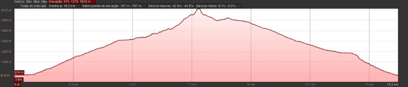
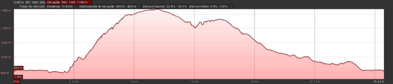
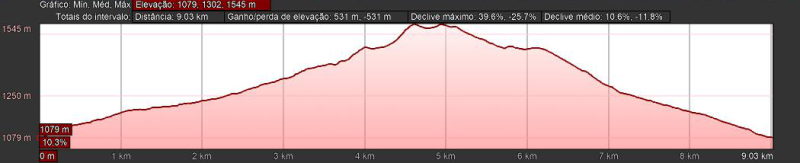
PRc-le55 ascensión al pico cueto (boñar)
Distância: 15,7 kms
Duração: 6h00m
Tipo: Circular
Dificuldade: Média
![](https://primary.jwwb.nl/public/t/f/x/temp-wponflgqgidooaehutvz/ala3xx/square_3578323537756d763777.jpg?enable-io=true&enable=upscale&crop=608%2C430%2Cx0%2Cy0%2Csafe&width=284&height=201)
![](https://primary.jwwb.nl/public/t/f/x/temp-wponflgqgidooaehutvz/thqxiy/Novaimagem-353.bmp?enable-io=true&enable=upscale&crop=1107%2C236%2Cx0%2Cy0%2Csafe&width=860&height=183)
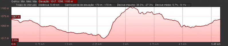
PRc-le56 por el río porma (boñar)
Distância: 3,5 kms
Duração: 1h10m
Tipo: Linear
Dificuldade: Baixa
![](https://primary.jwwb.nl/public/t/f/x/temp-wponflgqgidooaehutvz/9k1ern/square_72373136647279753671.jpg?enable-io=true&enable=upscale&crop=579%2C452%2Cx0%2Cy0%2Csafe&width=284&height=222)
![](https://primary.jwwb.nl/public/t/f/x/temp-wponflgqgidooaehutvz/jqlraj/Novaimagem-354.bmp?enable-io=true&enable=upscale&crop=1102%2C237%2Cx2%2Cy0%2Csafe&width=860&height=185)
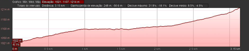
PRc-le57 las ermitas (boñar)
Distância: 10,4 kms
Duração: 4h30m
Tipo: Circular
Dificuldade: Baixa
![](https://primary.jwwb.nl/public/t/f/x/temp-wponflgqgidooaehutvz/iscpze/square_6e6f6f7271387136676a.jpg?enable-io=true&enable=upscale&crop=600%2C436%2Cx0%2Cy0%2Csafe&width=275&height=200)
![](https://primary.jwwb.nl/public/t/f/x/temp-wponflgqgidooaehutvz/4383ar/Novaimagem-355.bmp?enable-io=true&enable=upscale&crop=1108%2C236%2Cx0%2Cy0%2Csafe&width=860&height=183)
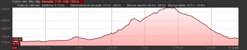
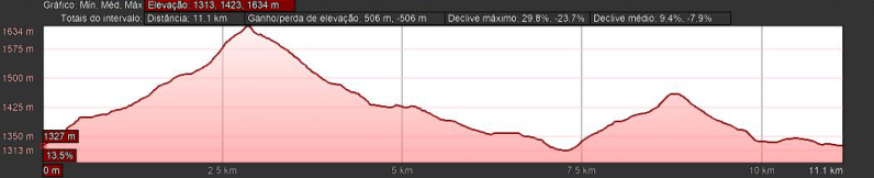
PRc-le58 camiño tradicional de adrados a vozmediano (boñar)
Distância: 11,8 kms
Duração: 4h30m
Tipo: Circular
Dificuldade: Média
![](https://primary.jwwb.nl/public/t/f/x/temp-wponflgqgidooaehutvz/s61df7/square_366f7874643678646170.jpg?enable-io=true&enable=upscale&crop=625%2C419%2Cx0%2Cy0%2Csafe&width=347&height=233)
![](https://primary.jwwb.nl/public/t/f/x/temp-wponflgqgidooaehutvz/mlj6vi/Novaimagem-356.bmp?enable-io=true&enable=upscale&crop=1106%2C236%2Cx0%2Cy0%2Csafe&width=860&height=183)
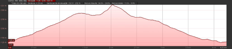
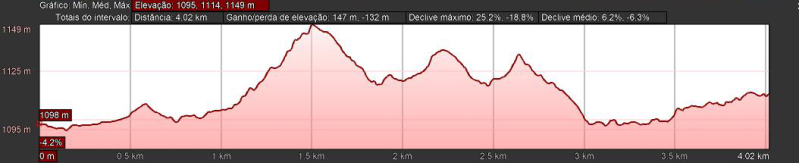
PRc-le59 por valdehuesa (boñar)
Distância: 4,2 kms
Duração: 1h45m
Tipo: Circular
Dificuldade: Baixa
![](https://primary.jwwb.nl/public/t/f/x/temp-wponflgqgidooaehutvz/zwoowm/square_3468736d373631723878.jpg?enable-io=true&enable=upscale&crop=629%2C416%2Cx0%2Cy0%2Csafe&width=311&height=206)
![](https://primary.jwwb.nl/public/t/f/x/temp-wponflgqgidooaehutvz/yx7cpa/Novaimagem-357.bmp?enable-io=true&enable=upscale&crop=1109%2C236%2Cx0%2Cy0%2Csafe&width=860&height=183)
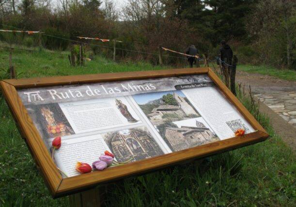
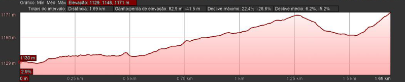
PRc-le60 ruta de las minas (sabero)
Distância: 9,8 kms
Duração: 3h00m
Tipo: Circular
Dificuldade: Baixa
![](https://primary.jwwb.nl/public/t/f/x/temp-wponflgqgidooaehutvz/kx0y52/square_6477773462716f766972.jpg?enable-io=true&enable=upscale&crop=611%2C428%2Cx0%2Cy0%2Csafe&width=311&height=218)
![](https://primary.jwwb.nl/public/t/f/x/temp-wponflgqgidooaehutvz/lsdyd3/Novaimagem-358.bmp?enable-io=true&enable=upscale&crop=1107%2C236%2Cx0%2Cy0%2Csafe&width=860&height=183)
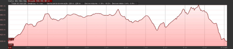
PRc-le66 villafañe-lancia (villasabariego)
Distância: 11,2 kms
Duração: 4h00m
Tipo: Circular
Dificuldade: Baixa
![](https://primary.jwwb.nl/public/t/f/x/temp-wponflgqgidooaehutvz/7tbz48/square_646965796f6676706230.jpg?enable-io=true&enable=upscale&crop=683%2C383%2Cx0%2Cy0%2Csafe&width=418&height=234)
![](https://primary.jwwb.nl/public/t/f/x/temp-wponflgqgidooaehutvz/ixk7et/Novaimagem-359.bmp?enable-io=true&enable=upscale&crop=1106%2C236%2Cx0%2Cy0%2Csafe&width=860&height=183)
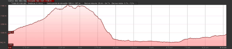
PRc-le74 ruta de los robles centenarios (la robla)
Distância: 15,6 kms
Duração: 4h30m
Tipo: Circular
Dificuldade: Média
![](https://primary.jwwb.nl/public/t/f/x/temp-wponflgqgidooaehutvz/n4rsfq/square_77637239623232746b77.jpg?enable-io=true&enable=upscale&crop=605%2C433%2Cx0%2Cy0%2Csafe&width=324&height=232)
![](https://primary.jwwb.nl/public/t/f/x/temp-wponflgqgidooaehutvz/8r9fb2/Novaimagem-360.bmp?enable-io=true&enable=upscale&crop=1101%2C237%2Cx0%2Cy0%2Csafe&width=860&height=185)
PRc-le75 ruta de las tresmarías (villamarín)
Distância: 11,2 kms
Duração: 3h30m
Tipo: Circular
Dificuldade: Média
![](https://primary.jwwb.nl/public/t/f/x/temp-wponflgqgidooaehutvz/epumtw/square_6a756439317463706762.jpg?enable-io=true&enable=upscale&crop=601%2C436%2Cx1%2Cy0%2Csafe&width=319&height=231)
![](https://primary.jwwb.nl/public/t/f/x/temp-wponflgqgidooaehutvz/b2ietb/Novaimagem-361.bmp?enable-io=true&enable=upscale&crop=1052%2C214%2Cx0%2Cy0%2Csafe&width=860&height=175)
SL-le3 camiño a utrero desde rucayo (boñar)
Distância: 4 kms
Duração: 1h15m
Tipo: Linear
Dificuldade: Baixa
![](https://primary.jwwb.nl/public/t/f/x/temp-wponflgqgidooaehutvz/e8ax2v/square_78383568707566317439.jpg?enable-io=true&enable=upscale&crop=618%2C422%2Cx1%2Cy0%2Csafe&width=344&height=235)
![](https://primary.jwwb.nl/public/t/f/x/temp-wponflgqgidooaehutvz/cx2750/Novaimagem-362.bmp?enable-io=true&enable=upscale&crop=1054%2C215%2Cx0%2Cy0%2Csafe&width=860&height=175)
SL-le4 ruta ermita de san pelayo (boñar)
Distância: 1,7 kms
Duração: 0h45m
Tipo: Linear
Dificuldade: Baixa
![](https://primary.jwwb.nl/public/t/f/x/temp-wponflgqgidooaehutvz/lwwun9/square_783338746c6d35763033.jpg?enable-io=true&enable=upscale&crop=591%2C443%2Cx0%2Cy0%2Csafe&width=268&height=201)
![](https://primary.jwwb.nl/public/t/f/x/temp-wponflgqgidooaehutvz/jsfkwr/Novaimagem-363.bmp?enable-io=true&enable=upscale&crop=1051%2C215%2Cx1%2Cy0%2Csafe&width=860&height=176)
SLc-le5 camiño tradicional de veneros a llama (boñar)
Distância: 5 kms
Duração: 1h20m
Tipo: Circular
Dificuldade: Baixa
![](https://primary.jwwb.nl/public/t/f/x/temp-wponflgqgidooaehutvz/uwxrfg/square_69336f70713163316e64.jpg?enable-io=true&enable=upscale&crop=610%2C429%2Cx0%2Cy0%2Csafe&width=328&height=231)
![](https://primary.jwwb.nl/public/t/f/x/temp-wponflgqgidooaehutvz/1z1ukt/Novaimagem-364.bmp?enable-io=true&enable=upscale&crop=1050%2C215%2Cx0%2Cy0%2Csafe&width=860&height=176)
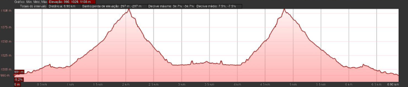
SLc-le6 ruta por el pinar de villares (boñar)
Distância: 9 kms
Duração: 2h40m
Tipo: Circular
Dificuldade: Média
![](https://primary.jwwb.nl/public/t/f/x/temp-wponflgqgidooaehutvz/zt9m3z/square_3279677738687878796a.jpg?enable-io=true&enable=upscale&crop=617%2C424%2Cx0%2Cy0%2Csafe&width=333&height=229)
![](https://primary.jwwb.nl/public/t/f/x/temp-wponflgqgidooaehutvz/n29cmq/Novaimagem-365.bmp?enable-io=true&enable=upscale&crop=1050%2C214%2Cx0%2Cy0%2Csafe&width=860&height=175)
SL-le2 cota de campillo (boñar)
Distância: 3,1 kms
Duração: 0h55m
Tipo: Linear
Dificuldade: Baixa
![](https://primary.jwwb.nl/public/t/f/x/temp-wponflgqgidooaehutvz/4rz2kc/square_71336d79786c63627767.jpg?enable-io=true&enable=upscale&crop=591%2C443%2Cx0%2Cy0%2Csafe&width=268&height=201)
![](https://primary.jwwb.nl/public/t/f/x/temp-wponflgqgidooaehutvz/y05lrf/Novaimagem-366.bmp?enable-io=true&enable=upscale&crop=1050%2C216%2Cx1%2Cy0%2Csafe&width=860&height=177)
SL-le7 senda de la mitología leonesa (riaño)
Distância: 5,1 kms
Duração: 1h40m
Tipo: Circular
Dificuldade: Baixa
![](https://primary.jwwb.nl/public/t/f/x/temp-wponflgqgidooaehutvz/8q7w64/square_6b756174636f36383672.jpg?enable-io=true&enable=upscale&crop=602%2C435%2Cx0%2Cy0%2Csafe&width=321&height=232)
![](https://primary.jwwb.nl/public/t/f/x/temp-wponflgqgidooaehutvz/n43ax4/Novaimagem-367.bmp?enable-io=true&enable=upscale&crop=1050%2C215%2Cx0%2Cy0%2Csafe&width=860&height=176)